Assam Tourism | Assam Map
About Assam:

Assam has a rich cultural heritage going back to the Ahom Kingdom, which governed the region for many centuries before the British occupation. Other notable features include the Brahmaputra River, the mystery of the bird suicides in Jatinga, umerous temples including Kamakhya of Tantric sect. 'Gurdwara Sri Guru Tegh Bahadur also known as Damdama Sahib at Dhubri '- This famous Gurudwara is situated in the heart of the Dhubri Town on the bank of the mighty Brahmaputra river in far north-east India. Guru Teg Bahadur the holy Sikh Guru visited this place in 1505 and met Srimanta Sankardeva (the founder of the Mahapuruxiya Dharma) as the Guru traveled from Dhaka to Assam, ruins of palaces, etc. Guwahati, the capital city of Assam, boasts many bazaars, temples, and wildlife sanctuaries.
Geography of Assam:

The countries viz. China and Bangladesh form international borders with Assam.
Assam is surrounded by a ring of blue hills. It is an amalgamation of plains and river valleys.Its principal geographical regions are: Brahmaputra Valley in the north; the Barak Plain in the south; and the Mikir and Cachar Hills that divide the two regions. These two largest valleys in Assam are the main lands where a large mass of human population live.
Assam weather:
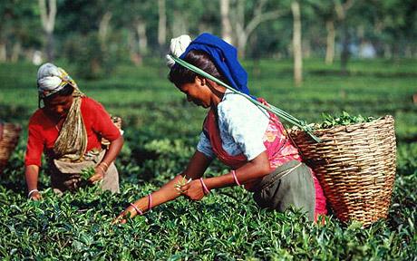
Assam Tea:
Assam is a black tea named after the region of its production, Assam, in India. Assam tea is manufactured specifically from the plant Camellia sinensis var. assamica (Masters). This tea, most of which is grown at or near sea level, is known for its body, briskness, malty flavor, and strong, bright color. Assam teas, or blends containing Assam, are often sold as "breakfast" teas. English Breakfast tea, Irish Breakfast tea, and Scottish Breakfast Tea are common generic names.

Though Assam generally denotes the distinctive black teas from Assam, the region produces smaller quantities of green and white teas as well with their own distinctive characteristics.
Historically, Assam has been the second commercial tea production region after southern China. Southern China and Assam are the only two regions in the world with native tea plants. Assam tea revolutionized tea drinking habits in the 19th century since the tea, produced from a different variety of the tea plant, yielded a different kind of tea.
Tourism in Assam:
Brahmaputra:

From its origin in southwestern Tibet as the Yarlung Tsangpo River, it flows across southern Tibet to break through the Himalayas in great gorges and into Arunachal Pradesh (India) where it is known as Dihang.It flows southwest through the Assam Valley as Brahmaputra and south through Bangladesh as the Jamuna (not to be mistaken with Yamuna of India). In the vast Ganges Delta it merges with the Padma, the main distributary of the Ganges, then the Meghna, before emptying into the Bay of Bengal.

The Brahmaputra's upper course was long unknown, and its identity with the Yarlung Tsangpo was only established by exploration in 1884-86. This river is often called Tsangpo-Brahmaputra river.
The lower reaches are sacred to Hindus. While most rivers on the Indian subcontinent have female names, this river has a rare male name, as it means "son of Brahma" in Sanskrit (putra means "son").
Guwahati:

The city is situated between the southern bank of the Brahmaputra river and the foothills of the Shillong plateau, with LGB International Airport to the west, and the town of Narengi to the east. The city is gradually being expanded as North Guwahati to the northern bank of the Brahmaputra. The Guwahati Municipal Corporation, the city's local government, administers an area of 216 km², while the Guwahati Metropolitan Development Authority, the planning and development administers an area of 340 km².

Guwahati and its environs are also rich in wildlife with several rare mammals such as Asian elephants, Gaur, Tiger and primates.The birdlife in and around the city is also rich and diverse.
Majuli:

The island is formed by the Brahmaputra river in the south and the Kherkutia Xuti, an anabranch of the Brahmaputra, joined by the Subansiri River in the north.Majuli island is accessible by ferries from the City of Jorhat.The island is about 200 kilometres east from the state's largest city — Guwahati. The island was formed due to course changes by the river Brahmaputra and its tributaries, mainly the Lohit. Majoli is also the abode of the Assamese neo-Vaisnavite culture.
Kaziranga National Park:

Kaziranga is a vast expanse of tall elephant grass, marshland, and dense tropical moist broadleaf forests, crisscrossed by four major rivers, including the Brahmaputra, and the park includes numerous small bodies of water. Kaziranga has been the theme of several books, songs, and documentaries. The park celebrated its centennial in 2005 after its establishment in 1905 as a reserve forest.
Tezpur:

Jatinga:
Jatinga , a village on a ridge, is located in Dima Hasao district, Assam State in India. It is 330 km south of Guwahati. It is most famous for the phenomenon of birds “committing suicide”. Although the birds do not commit suicide and are actually killed, the phenomenon of suicide has spread far and wide among common people. The village is inhabited by about 2,500 Jaintia tribal people.
Sibsagar:

Hajo:
Hajo is an ancient pilgrimage centre for three religions: Hindus, Buddhists, and Muslims. It lies on the banks of the Brahmaputra River, 24 km from the city of Guwahati in the Kamrup district of Assam, India. The area is dotted with a number of ancient temples as well as other sacred artifacts. The Hayagriva Madhava Mandir is the most famous temple of Hajo. Lesser known temples of Hajo like that of Ganesha was constructed during the reign of Ahom King Pramatta Singha in 1744 AD. The Kedareswara Temple, a Shiva temple, has inscription on the temple showing that it is of Rajeswar Singha period.
Hayagriva Madhava Temple is situated on the Monikut hill. The present temple structure was constructed by the King Raghudeva Narayan in 1583. According to some historians the King of Pala dynasty constructed it in 6th century. It is a stone temple and it enshrines an image of Hayagriva Madhava. Some Buddhists believe that the Hayagriva Mahhava temple, best known in the group of Hindu temples, is where the Buddha attained Nirvana. At this imposing temple, the presiding deity is worshipped as the Man Lion incarnation of Vishnu by the Hindus. It is a stone temple and it enshrines an image of Hayagriva Madhav. The rows of elephants are seen on the body of the temple and they are fine specimens of Assamese art. There is a big pond known as Madhab Pukhuri near the temple. Doul ,Bihu and Janmastami festivals are celebrated every year in the temple. Moreover this temple preaches both Hinduism and Buddhism, which attract Buddhist Monks from far flung places. Sayani, the first wife of Kalia Bhomora Barphukan donated a family of paiks and also a plot of land for their maintenance to the Hayagriva Madhava temple during the days of Purnananda Burhagohain.
Hajo is also a Muslim pilgrimage centre since the mosque known as the Poa Mecca is thought to have some of the sanctity of Mecca.
Haflong:

Tinsukia:

Tinsukia is a business city in the Indian state of Assam. It is situated 480 kilometres (298 mi) north east of Guwahati and 84 kilometres (52 mi) kilometres away from the border with Arunachal Pradesh. It is the administrative headquarters of Tinsukia District of Assam, India. Hailed as the business capital of Assam, the place has a heady mix of Assamese, Bengali and Hindi-speaking people. The city is changing with the construction of numerous new malls and buildings. In ancient times Tinsukia was known as Bengmora. It was ruled by Sarbanada Singha, a Matak King. The present name of the place came from the Tinkunia Pukhuri (the pond with three sides) located at the heart of the city. Tinsukia is also a major railhead of Assam. Presently it houses the biggest railway junction of Assam. One can travel there either by train or by flight to Dibrugarh and then a taxi. Tinsukia acts as a link to many a towns of the north east of India.
Jorhat:

Assam Photos:


Assam Map:


